
Frequently asked questions about phase one of the GRRIN extensions project
The Gautrain Management Agency (GMA), in collaboration with affected communities, has compiled the following FAQs regarding the proposed Gauteng Rapid Rail Integrated Network (GRRIN) extensions.
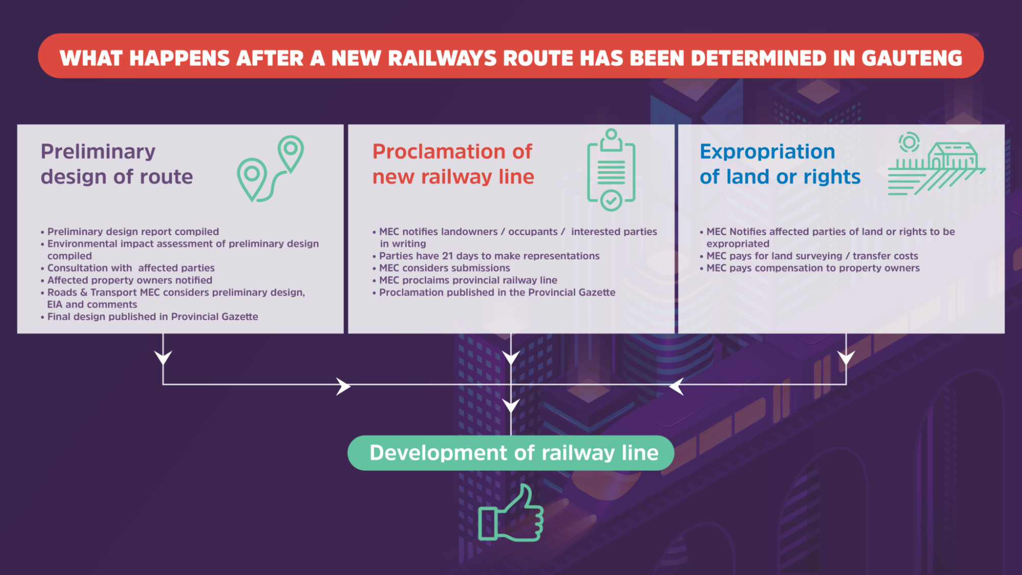
Please also refer to these infographics, which outline the comprehensive process of determining, designing, planning and implementing a new provincial railway line, with several opportunities for public participation and stakeholder input.
- Find information on the proposed route here: https://bit.ly/3QbxzgU
- Email for inquiries and comments:
FAQs
1. Why does the route not go underground, as was done for Sandton, which would be less invasive, and has minimal impact on the public and the environment? Is it a matter of timing or cost?
The development of public infrastructure such as the rapid rail network requires due consideration of, among other factors, its potential economic, environmental and social impact. The extent to which the proposed route is above or below ground is thus a function of minimising environmental and social impact while maximising the economic impact at the least possible implementation and operational cost.
2. What is the purpose of the objection/comments process? Is the government held (legally or otherwise) to anything that comes out of the process, such as overwhelming objections to a particular route?
The process of determining a route for a provincial railway line in Gauteng is legislated through section 6 of the Gauteng Transport Infrastructure Act (GTIA), as amended in 2003. This is the first step in the process of defining the rail reserve for the future railway line. The process of soliciting comments from interested and affected parties is a requirement in the GTIA. All comments that are received are collated and evaluated on their merits for due consideration as part of the process to determine the final route.
The next step in the process is to undertake the preliminary design of the proposed railway system and will include a full Environmental Impact Assessment (EIA). This is also a legal requirement in terms of the GTIA and entails further consultation with all interested and affected parties.
3. Will the findings/outcomes of the comments/objections process be made public?
All of the comments that are received by the GMA are responded to accordingly. Furthermore, these comments and the responses to them are collated into a report that, together with the proposed route alignment documentation, will be presented to the MEC for Public Transport and Roads Infrastructure to consider as part of the process to determine the final route. The MEC may refer specific issues to an independent commission. During this process, the issues referred to this commission are published and anyone who is directly affected by them is invited to provide further comments. Thereafter, this commission will make recommendations to the MEC on the final route that will be published thereafter.

4. Which communities are being targeted with this proposed extension?
The Gauteng Rapid Rail Integrated Network (GRRIN) forms part of the broader public transport system envisaged for the province, which is designed to provide all residents and visitors with enhanced mobility and connectivity in Gauteng.
5. What public participation process is being followed to allow the public to ask questions and receive responses?
The legislated process required that the proposed route/s be published in the Provincial Gazette and for the interested and affected parties to provide written comments thereto. The GMA has, over and above this legislated requirement, during the period 15 July 2021 – 16 August 2021 published the notice, including inviting the submission of any comments, in the Sowetan, Star, Randburg Sun, Die Beeld and Sandton Chronicle. This information has also been made available on various digital platforms, including social media.
All documentation related to the route that was determines on 25 May 2-022 for Phase 1 that connects from the existing Malboro Station to Little Falls through Sandton, Randburg, and Cosmo City is available on the GMA’s website at: https://bit.ly/3QbxzgU
The GMA welcomes any enquiries related to this process and these can be made through by email to extensions@gautengrapidrail.co.za
The stakeholder consultation process will continue as more details become available during the next phases of the development of the project, starting with the preliminary design and the EIA that will be undertaken after the conclusion of the determination of the route.
6. What are the project timelines?
The determination of the route is the first phase of the process of defining the railway reserve for the proposed GRRIN extensions, and forms part of the preparatory work required to enable a project of this nature to be implemented. As such, the commencement of the implementation of the project is not envisioned to occur before 2026.
7. Will homeowners not directly impacted be compensated due to a train line running not far from their homes? How will this affect property prices?
The compensation for properties to be expropriated or the rights of use required to enable the development and operation of the proposed railway line will be in accordance with the GTIA. Various studies that have been commissioned to investigate the economic impact of the Gautrain have, among other findings, revealed that properties located near its stations have been impacted positively. This trend is expected to continue with the proposed extensions.
8. Will the GMA allow people to ask questions directly?
The process of submission of comments and/or enquiries related to the determination of the route articulated in question 5 above directs all of these queries to the GMA. All comments, questions and/or enquiries received by the GMA will be responded to accordingly. The GMA will remain available to respond to any further comments or enquiries that are received in regard to the GRRIN extensions project and the process that it will be following.
9. Will details of environmental mitigation measures be provided?
The next phase of the process to define the railway reserve is the Preliminary Design that includes a full Environmental Impact Assessment (EIA). This phase also entails a consultation process with the affected parties, including making copies of the preliminary design and EIA reports available for public comment.
10. Will all the roads affected be permanently closed? How will this affect commuters during and after construction?
It is the aim of the project to keep all major roads open, as well as access to all of the properties. Roads will only be closed if they no longer serve a purpose. The movement of commuters and vehicles will be ensured through detailed traffic management plans that will be applicable during the construction phase.
11. Is the new line a done deal and is it now down to which route is chosen?
Definitely not. If there are any substantial comments that may have an impact on the route, then these comments will be taken on board and the alignment will be adjusted accordingly. It must also be stated that the route determination is only the first step in the process (please refer to infographics for a snapshot of the process).
When the final route is published, then a strip of 200m on either side of the route will be protected by the province. The preliminary design, which is the next step in the process following the initial call for public submissions on the route determination, will further refine the route in order to get to the optimum alignment.
12. Will the route only benefit those living around the proposed stations, as people living along the route cannot catch the train?
The phase that is undergoing the current process of determining the route comprises new stations at Little Falls, Cosmo City and Randburg. Access to these stations and thus the GRRIN will be supplemented by, among other transport options, various feeder and distribution services such as buses.
13. Will any of the stations become a taxpayer-subsidised facility that devalues the properties of the people paying for it?
The proposed extensions are based on a comprehensive feasibility study that was undertaken to investigate, among other factors, the need to service the identified nodes with a rapid rail system.
14. Before Covid-19, the existing Gautrain routes were widely used, but many people who used to use the Gautrain are now working from home and the facility is not as well used. Why is another route necessary?
The Gauteng Provincial Government, in 2013, completed a 25-year Gauteng Integrated Transport Master Plan (ITMP25) that was commissioned to enable, among other benefits, province-wide mobility and societal development in the future. As part of the development of this ITMP25, traffic modelling was done on the current and planned key road network for Gauteng. This modelling was undertaken with due regard to predicted population growth, strategic spatial and development planning, as well as private vehicle ownership. From 2025, the province is predicted to experience significant increases in traffic congestion, travel times and associated challenges, including greenhouse gas emissions. The GRRIN extensions will therefore form part of a modernised and integrated transport system that enables sustainable mobility in Gauteng in the future.
Although the Covid-19 pandemic will have a significant impact on mobility in the short to medium term, with more information becoming available with regard to measures taken to mitigate the pandemic, passenger volumes are on the increase and are projected to continue doing so over time. Thus, the extension of the GRRIN will, in the long term, enable people to enjoy increased mobility and connectivity to other parts of the province.
15. Has a feasibility study been undertaken to ensure that these proposed Gautrain routes will be used, or will they become a white elephant?
A comprehensive feasibility study was undertaken for the proposed extensions to the GRRIN. Completed in 2016, the study concludes that the GRINN extensions will provide significant economic and transport-related benefits to both the province and the country while offering value for money and appropriate risk transfer if procured as a public-private partnership (PPP). This study is currently subject to the National Treasury approval process that will enable the commencement of the procurement for phase one.
16. How will the power cables, water pipes and sewage lines that will be affected be handled to avoid inconvenience to residents?
Part of the route determination process is to also investigate the potential impact the alignment will have on existing bulk services in more detail. It can be confirmed that properties will retain their services and that any interruption will be temporary and clearly communicated during construction. The learnings from the implementation of the existing Gautrain project – during which existing services that were affected were relocated, modified and protected during the early works so as to ensure that no service delivery issues would be experienced in the major construction phase – will be applied in the development of the proposed extensions.
Additional FAQs
1. Are there detailed maps showing which properties will be affected and/or demolished on each route proposal?
The proposed routes have yet to be refined. The route determination process that is currently underway is legislated through section 6 of the Gauteng Transport Infrastructure Act (GTIA), as amended in 2003. This is the first step in the process of defining the rail reserve for the future railway line. The purpose of this process is to identify the best possible route which, when determined, will result in a strip of 200m on either side of the proposed alignment that will be protected by the province.
The preliminary design process, which is the next step after route determination, will further refine the route to get to the optimum alignment. This will then enable the MEC for Public Transport and Roads Infrastructure to, after consultation with registered owners and holders of registered rights relating to the affected properties, as well as other parties that will be affected by the proposed extensions, proclaim the railway reserve.
2. How will existing infrastructure be upgraded as part of the development in the affected areas?
Although part of the route determination process that is currently underway includes a high-level investigation of any potential clashes between the proposed alignment and existing bulk services, the impact on the capacity of bulk services infrastructure can only be confirmed during the detailed design stage that will commence after the conclusion of the preliminary design process.
Any requirement for existing services to be relocated, modified or protected to enable the development of the proposed extensions and is foreseen to cause any service interruption will be temporary and clearly communicated with affected parties during the construction.
3. Are maps available that show the embankments and cuttings for each route proposal?
The preliminary design process, which is the next step after the route determination process that is currently underway, will further refine the route and provide information on the configuration of the proposed Gauteng Rapid Rail Integrated Network (GRRIN) extensions, including details such as the extent and locations of embankments, cuttings, cut-and-fill toe lines, tunnels, viaducts, bridges, service roads and fences.
This information will be made available to registered owners and holders of registered rights in respect of the properties, as well as other parties that will be affected by the proposed extensions. Therefore, interested and affected parties will be afforded opportunities to provide their comments during the preliminary design process and the project as a whole. In effect, this means that public participation does not end with the route determination process.
4. Can maps be made available to show more detail, for example the proposed viaducts crossing of N1?
There are three route options that have been published for public comment. Although all three of these options cross the N1 highway above ground, this will be achieved by means of either a viaduct or a bridge, depending on the route concerned. Although further details on how the proposed alignment will traverse existing infrastructure will be defined during the preliminary design process, which is the next step after the route determination process that is currently underway, the N1 will stay open.
5. What will be the impact on the current road network?
The preliminary design process, which is the next step after the route determination process that is currently underway, will provide further details on the extent to which the proposed GRRIN extensions will impact the current and planned road network.
It is the aim of the project to keep all major roads open as well as to enable access to all the properties. Roads will only be closed if they no longer serve a purpose. The movement of commuters and vehicles will be assured through detailed traffic management plans that will be applicable during the construction phase.
6. Would a combination of proposed lines be considered?
All comments on the proposed route alignment options are welcome, and once received by the Gautrain Management Agency (GMA), will be considered as part of the process to determine the optimal route.
7. What will the impact be on the low-cost housing developments that are being planned?
The development of the GRRIN extensions projects is being undertaken with due consideration of the existing and future spatial and development planning of the local and provincial spheres of government. Any changes to this planning that may impact the GRRIN extensions project will be established and managed as part of the ongoing consultation that will continue throughout the development of the project.
8. Why does Gautrain not look at a tramway system, which can carry more people cheaper and could be cheaper to develop?
Light rail systems have a place in a modernised and integrated public transport system that is envisaged in the 25-year Gauteng Integrated Transport Master Plan (ITMP25), which is also the basis of the proposed GRRIN extensions. The current extensions are intended to enable enhanced mobility in the Gauteng city-region, which entails higher speeds over longer distances, whie tramway systems are best suited for slower and more localised systems.
9. Why are the proposed stations positioned where they are?
A comprehensive feasibility study was undertaken for the proposed extensions to the GRRIN. Completed in 2016, this study is currently subject to the National Treasury approval process that will enable the commencement of procurement for phase one. The planned stations are as per the outcome of the said feasibility study. Access to these stations and the broader network will be supplemented by, among others, various feeder and distribution services through which coverage to areas such as Olivedale can be achieved.
10. How will the line be secured?
The security regime that has been applied on the current Gautrain system will continue to be applied to the proposed GRRIN extensions and entails a combination of passive and active human, as well as physical and technological, security infrastructure that will be in place for 24 hours of every day.
11. Please elaborate on blasting and soil/ground disturbances during construction.
The preliminary design process, which is the next step after the route determination process that is currently underway, will provide further details on the extent to which the proposed GRRIN extensions may cause temporary soil or ground disturbances, including any requirements for blasting.
12. Will the spruit that runs through the area require rerouting or channelling?
The preliminary design process, which is the next step after the route determination process that is currently underway, includes the undertaking of a full environmental impact assessment (EIA). If the outcome of the preliminary design stage requires the rerouting or channelling of the spruit, this will be incorporated into the design and assessed as part of the EIA.
13. There are new high-density developments being proposed along the route – what will happen to them?
The preliminary design process, which is the next step after the route determination process that is currently underway, and entails further consultation with interested and affected parties, will further refine the route and provide detail on which properties and to what extent they respectively fall within the rail reserve.
Thereafter, engagements with the respective registered owners and holders of registered rights in respect of the affected properties will commence with regard to compensation for properties to be expropriated or rights of use required to enable the development and operation of the proposed GRRIN extensions in accordance with the GTIA.
14. Why not use cheaper open-cast tunnelling?
The development of public infrastructure such as the rapid rail network requires due consideration of, among other factors, its potential economic, environmental and social impact whilst minimising capital and operational costs. Optimal methods of implementing the proposed GRRIN extensions are therefore part of the development of the project and the extent to which alternative construction methods can be applied will be investigated during the detailed design stage.
15. Quite a few of the tunnels appear shallow – does that mean open-cast tunnelling?
The information as contained in the documentation that was made available to enable participation by all interested and affected parties is only to the extent to enable the route determination process to proceed. Preliminary design, that is the next step after the route determination process, will, after further detailed investigations that include a full EIA, provide further details on the extent to which the proposed railway will be below or above ground, including the depths of the respective tunnel sections. Optimal construction methods for the proposed GRRIN extensions, and thus the extent to which alternative construction methods can be applied, including open-cast tunnelling, will be investigated as further detailed design information becomes available, starting from the preliminary design phase.
16. Why is 200m needed each way as a reserve?
The 200m distance measured from either side of the centre line of the route to be determined provides the province with a reasonable amount of land on which the proposed railway can be designed in compliance with the applicable geometric and other standards that are necessary to enable the realisation of safe and optimal construction, as well as operation, of a rapid rail system. This distance is prescribed in the Gauteng Transport Infrastructure Act (GTIA), whose prescripts are applied in the process to eventually define the rail reserve.
This 400m-wide strip of land does not form part of the rail reserve in its entirety, as the proclamation of the rail reserve only takes place after the conclusion of the preliminary design process that is undertaken after the conclusion of the route determination. The alignment that will be selected as part of this route determination process, after consideration of all submissions received from interested and affected parties, goes through further refinement during this preliminary design phase. This phase will also provide more information on, among other factors, the extent to which the determined route will be located below ground, above ground or at grade.
Therefore, the width of the rail reserve will vary depending on the characteristics of the various sections of the alignment, but will be narrower than the 400m, the extent of which will be confirmed during the preliminary design process.
The route determination process enables the province to protect this 400m-wide strip of land until the rail reserve is proclaimed. The implication for the properties falling within this protected strip of land is that should any local authority in whose jurisdiction the determined route in located, receive an application for any proposed land-use change that falls within this 400m-wide strip of land, that local authority is required to forward such an application to the MEC for Public Transport and Roads Infrastructure for comment prior to the approval of such an application by that local authority.
17. What about residents who are scared they will not be able to sell their properties when the route has been proclaimed, even though it may take 20 years before anything happens?
The compensation for properties to be expropriated or land rights required to enable the development and operation of the proposed railway line will be in accordance with the GTIA. In this regard, the proclamation of the rail reserve will only take place after the affected properties have been expropriated and the affected property owners have, after extensive consultation, been compensated for either the land or rights on the land. This compensation includes the cost for the surveying of the affected land, as well as the transfer costs.
Although the ownership of the expropriated property shall vest with the province on the date of expropriation, the property owner is entitled to the use of and income from the property, and remains responsible for the rates and taxes and other charges in relation to the property, as well as its maintenance, until the province takes possession of the property on a date to be agreed between the MEC and the owners of the respective properties.